
TOUR KANCHANABURI
Kanchanaburi is a old city of Thailand Located west.Kanchanaburi city of waterfalls and nature Erawan waterfall Kanchanaburi, Mae Klong Dam. dam Sawat A rafting Yok And visit the Bridge on the River Kwai. Museum and Tomb Death Railway World War 2. When military axis (coalition) was a Japanese soldier held captive. Relive the old days Bought stones Kanchanaburi Jewelry valued Cross the bridge and watch the way of life in Thailand at the Mon Sangkhlaburi.
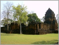
1.Bridge over the Khwae Yai River
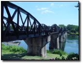 Located in Tambol Tha Makham,approximately 4 km. to the north of the city on Highway 323, with a left turn for some 400 metres. A site of significant historical importance, the bridge was built during World war 2 under the supervision of the Japanese Army by Allied POWs comprising of 61,700 British, American, Australian, Dutch and New Zealand soldiers and a large number of Chinese, Vietnamese,Japanese, Malaysian, Thai , Burmese and Indian labourers. It was part of the strategic. railway linking Thailand with, then Burma. The painstaking construction of the Bridge over the Khwae Yai River – River Kwai as it is known among foreigners, brutalities of war, diseases and starvation claimed thousands of lives of the POWs.
A Fairmong tram service is available daily at the bridge during 8.00 – 9.30 a.m.,11.20 a.m. – 2.00 p.m.,3.00 – 4.00 p.m. and 6.00 – 6.30 p.m. on weekdays, and 8.00 – 9.30 a.m.,11.20 – 2.00 p.m. and 6.00 – 6.30 p.m. on weekends The fare is 20 bath
2. Kanchanaburi War Cemetery (Don Rak)
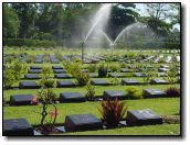 Every Today in war cemetery you will people or tourism walk in and remember about soldiers. Kanchanaburi War Cemetery build in 1993.
located on saeng Chu To Road (Highway 323) before reaching the provincial town. The immaculately maintained cemetery contains the remains of 6,982 Allied POWs who perished during the construction of the ” Death Railway”. Its tranquility remands the visitors of the war and its after-effects. For more information,call tel. (+66)034511500
3.Death Railway
The strategic railway tracks began from Nong Pla Duk station in Amphoe Ban Pong, Ratchaburi,and ran via Kanchanaburi across the Khwae Yai River,westbound to the Three Pagodas Pass, to end at Thanbuyuzayat in Burma. The total distance within the Thai territory was 300 km.,taking only one yare to complete from October 1942 1942 – October 1943. After the war, some part of the tracks was demolished and some submerged under the lake of Khao Laem Dam. The Death Railway is a reminder of the cruel war and its painstaking construction by the Allied POWs. It runs through a scenic landscape,especially the area of Tham Krasae where it skirts the cliff overlooking the Khwae Noi River .The railway currently ends at Ban Tha Sao or Namtok Station, a distance of some 77 km. from Kanchanaburi Station. A special train running from Bamgkok to Namtok station is available on weekend and national holidays.For further details’please contact the State Railway of Thailand, Tel.1690 or (+66)022204334
4.Thailand – Burma Railway Center
Located near the Kanchanaburi War Cemetery (Don Rak) itputs on an exhibition of history of the Thailand – Burma railway from the invasionof the Imperial Japanese army.planning and construction in POW camps. medical aspects. summary of deaths,operation.bombing and end of the railway ,as well as aftermath of the war. Open daily during 9.00 a.m. – 5.00 p.m.
Admission is 60 bath for adults and 30 bath for children under 12 year. for further details, please call Tel (+66)034510067
5.Jeath War Museum or Wat Tai War Museum
located within Wat Chai Chumphon Chana Songkhram (wat tai), tombon Ban Tai, approximately 300 metres from saeng Chu To road. The bamboo building of the museum imitates an Allied POWs camp during World War 2 and exhibits a collection of photographs, drawings and articles that reflect the living conditions of the POWs, as well as tools, armaments and bombs from wartime. Open daily during 8.00 a.m. – 6.00 p.m.Admission is 30 bath.
6.Kanchanaburi Cultural center
Located inside Rajabhat University Kanchanaburi, Tombon Nong Bua,on the Kanchanaburi – Sai yok route (Highway 323), some 15 km. from the province. The ground floor exhibits household utensils and tools for daily use as well as fishing gear. The upstairs houses exhibition rooms on history, religions and traditions,old Thai scriptures and various art objects.
There are excavation pits nearby.The cultural centre is open daily,except for Wennesdays, during 8.30 a.m. – 4.30 p.m.
7.Ban Kao National Museum
Located on the Kwai Noi River at Tambon Ban Kao, Amphoe Mueang, approximately 35 km. from Kanchanaburi along Highway 323,turn left into Highway 3229 and turn right into Highway 3445 for about 3 km. Another 1 km. from the entrance at Wat Tha Po will lead to the first prehistoric site museum in Thailand where human skeletons and artefacts such as stone axes,ornament and pottery were unearthed in situ in 1963.The museum is open daily during 9.00 a.m. – 4.30 p.m.
8. Khao Chon Kai Training Camp
Located 150 km. from Bangkok and some 20 km.from Kanchanaburi, about 3 km. on Highway 3199 ( Kanchanaburi – Srinagarindra Dam) It is a training camp for national army reserve students and ,out of the training season,open for the public to visit hostorical sites as well as enjoy certain military activities such as tower jumping, shooting and jungle survival.
Accommodation is available. For futher details the office of Tourism,Department of Territorial Defence, Tel (+66)022212871 or Khao Chon Kai Tourism Office, tel(+66)034589237
9.Nine Army Battle Historical Park
Located at Thung Lat Ya in Tambon Chong Sadao , some 40 km. from Kanchanaburi. Take Highway 3199(Kanchanaburi – Srinagarindra Dam) to Km.24 .The Park seves as a source of data on the historic nine – army battle under the royal command of King Rama 1 in defennse of the kingdom against the invasion of King Bodawpaya of Burma in 1785.
The battle at Thung Lat Ya contributed to Thailand ‘s national sovereignty having been sustained until the present .
The exhibition building houses dioramas of the battle scenes and a sand table displaying the topography as well as route taken by the Burmese troops.There is an observation tower for visitors to better understand how to take advantage of the topography in the battle. Open daily during 8.30 a.m.- 5.00 p.m. Admission is 20 bath.
10.Mueang Sing Historical Park
Better know as Prasat Mueang sing located some 7 km. from Ban Kao National Museum. Take Highway 323 (Kanchanaburi – Sai Yok),turn left at Km.15, and continue for another 7 km. to Prasat Mueang Sing.
The laterite sanctuary was constructed in the late Lop Buri Period ca. 11th-13th century A.D. It has a square plan covering a total area of over 800 rai and surrounded by a laterite wall measuring 880 metres wide. Influenced by ancient Khmer culture, Its principal tower is encircled by a laterite wall, moat and earthen mound and was built in a mixture of the folk school of art and Bayon style of King Jayavarman VII’s period in Cambodia. The Park is open daily during 8.00 a.m. – 4.30 p.m.
11.Maize Maze
Is situated in the Agricultural and Cooperative Division, the Royal Thai Armed Forces Deveopment Command ( Khao Khat) ,with an area of 26 rai (41,600 square metres)Both side of the road inside the Maze are covered with maize travel and there is also a sunflower field,so tourists do not have to travel further to Lop Buri.Moreover, a 34 -foot high watchtower is available for visitors who love the challenge of heights.
They can climb up to admire the beatiful scenery and take bird’s eye view photographs of “Maize Maze” opens at 9.00 a.m.- 4.00 p.m. . Admission for adults is 30 bath and children or students is 10 bath.
12.Mon Bridge


located in Amphoe Sangkhla Buri. it is also called ” Saphan Uttamanuson” This is the longest wooden bridge in Thailand with the lenght of 850 metres crossing Huai Song Ka Lia where people in Amphoe Sangkhla Buri and Mon Villge travel back and forth. This place is another great sight – seeing point of Vajiralongkorn Dam where many creeks; Song Ka Lia, Bi Khli and Ran Ti, meet together leading to ” Sam Prasop”
13.Pilok Mine
located in Tambon Pilok some 70 km.to the west of Amphoe Thong Pha Phum along Hightway 3272.There used to be tin and wolfram mines on the Tanao Si Range which form a natural boundary between Thailand and Myanmar. On the way,visitors can stop at “Pilok Hill “, abouth 32 km. from Thong Pha Phum where fruiting and decorative plants of the temperate zone are grown. There are numerous picturesque waterfalls nearby which are accessible by foot such as Namtok Chokkadin and Namtok Chet Mit. Visitors need to be careful because most of the routes are steep and winding.
14.Suan Wela Ramluek


It is a garden inside the Srinagarindra Dam with an area of 30 rai (48,000 square metres).EGAT constructed this garden in honour of Her Royal Highness Princess Srinagarindra, the Princess Mother,on the occasion of her 90th birthday anniversary on 21 October,1990 .The garden was built to place sculptures implying about “time” For instance, a symbol of a sundial reminds people to be awareof the value of life which walks through time every minute. It is similar to Her Royal Highness the Princess Mother who always spent time valuably without wasting a second
15.Three Pagodas Pass
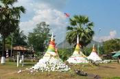
The end of the Thai border in the west is located in Tambol Nong Lu on Highway 323, about 4 km. before getting to Amphoe Sangkhla Buri. Turn into the intersection on your right and continue for 18 km.to get to the Three PagodasPass.All routes are asphalted.In the past, the ThreePagodas Pass was called ” Hin Sam Kong”(Three piles of rocks)respected by Thais who always passed through the border. Later,in1929 Phra Si Suwannakiri,Sangkhla Buri Governor at that time,led villagers to build three small-sized pagodas. In addition,the Three Pagodas Pass was also one of the crucial military routes of Siam and Burma.
At present,lots of shops selling products from Myanmar are placed around the border where tourists can pass through to the Phaya Tong Su Market in Myanmar, a border market full of Burmese products. The passopens 8.00 a.m. – 6.00 p.m.
16.Erawan Waterfall


Erawan is a famous tourist destination of Kanchanaburi. Each day there are a lot of tourists, both in Thailand and overseas. A beautiful waterfall in the middle of the jungle and natural water pools for swimming among the trees. There are many facilities for tourists. Bus ride possible. And not far from the city.
Erawan waterfall in Erawan National Park. Srisawat In line River Kwai Covering an area of about 600 square kilometers On Route 3199, which is the same path to the lake.
Formerly Erawan Falls “waterfall convenient to look striped” derived from upstream. Name streams Mong And Las ageless Creek Erawan Waterfall is a large waterfall Water flows down from the high peaks over rocks and cliffs covered with lush forest species. As well as a range of other basins. Causing a layer of water fall. A beautiful vary. Waterfall with all seven layers, each layer is called consonance. From the first floor to the seventh floor is the “Night Macha Wang Pha Rung Waterfall her chest butterfly bored into the mountain jungle foliage Erawan” waterfall Each class has a different distance from the floor to the other, just a few hundred meters. 1520 meters until the top layer, which took nearly an hour to walk through the woods up to the top floor. Break open a cliff Some of them seemed quite steep and slippery top layer Many say that shaped rock looked similar to the Erawan Museum Erawan. It is the source of Erawan waterfall itself.Erawan Falls are exceptionally beautiful. Match the color of the water is clear blue. Like the pool Because the water through the limestone. A high calcium carbonate Has made settling suspensions If the area does not have a swim in the crystal clear water. Falls in the early As the water falls, the fish species called “fish antimony” has seen a lot of Erawan waterfall is like walking through the woods should not be missed because he can play in each class they want. The icy waters of the waterfall over rocks with distinctive characteristics. Beautiful, different on each floor. In addition, visitors will be playing in a puddle of water. You can also walk up to the top floor as well. Erawan waterfall has water throughout the year during the dry season months of December to April may be less certain. But it does not dry upCar park Are arranged in an orderly, beautiful waterfalls in the beginning. Is too much To go to the first waterfall. Must walk another 500 meters
Layer 1 Night Falls nest was not very pretty. Perfect for a picnic There are tables and chairs for seating Eating waterfall
Layer 2 General Wang Macha fish circle swimming in clear water in a number of pools, waterfalls, flowing blue curtains and stalactites. As water flows through the cave Down to a large basin Ideal for swimming Some may deepen Visitors can rent a lifeboat into play.
Layer 3 story waterfall cliff waterfall before ascending to this waterfall. Do not bring food to checkpoints food, drink and water bottles to the floor this time. Leave it to authorities
Layer 4 her chest butterfly park corridor stair neatly. But the path is fairly steep as well. On the way to the waterfall with four nature trails evergreen Mong distance of 1010 meters, walking along the path that separates this class, you will see two stone cube that looks like a bust. It looks bigger than human. She has named her chest butterfly (Ocean) so that this layer of water on the rocks down to the basin below. You can swim
This route is somewhat more difficult. And a steep rise indefinitely. To top tier waterfall
Layer 5 is fed into a waterfall cascades down a scrub. A shallow basin Suitable for water play
Layer 6 Dong flora from the five-story, 300-meter waterfall on several fronts. According to various trees
Pha Erawan
Layer 7 of arrival. Walk through the stone Climb the stairs to the next As tired as well. But it’s worth a look. It is the top of the tallest and most beautiful. The water falling from the cliffs through the trees and rocks into a pool below.
(Thank You for data from pantip and manager)
